Five years ago, The Weather Channel announced a new, immersive weather presentation tool, powered by Unreal Engine, that uses mixed reality to better depict major weather events. Since then, it’s been regularly used on TWC for weather reports and storm warnings, though it’s most effective (and memorable) when depicting severe weather, like showing viewers how wildfires spread. Today, that tech is being used yet again to showcase the potential storm surge from Hurricane Milton, one of the biggest storms in recorded history, set to make landfall in Florida later today, October 8—and it’s terrifying.
Hurricane Milton is expected to bring a destructive storm surge to Florida's west coast. @StephanieAbrams uses our FloodFX simulation technology to show you what that could look like ⬇️ pic.twitter.com/rg996zNHy2
— The Weather Channel (@weatherchannel) October 8, 2024
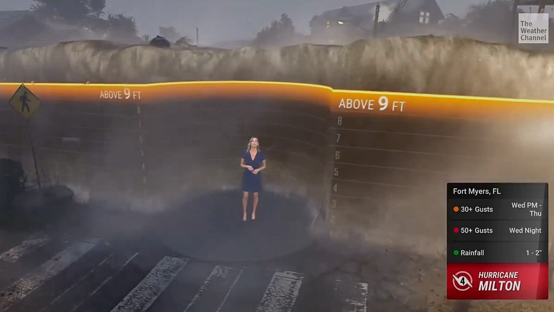
Using the Weather Channel’s FloodFX simulation, meteorologist Stephanie Abrams showed just how bad the storm surge could be from the incoming hurricane in a clip shared to X (formerly Twitter) earlier today. The mixed reality setup is chillingly effective: Abrams stands in a completely virtual space, the camera zooms out to make it seem like she’s standing on a street in Florida, while a smaller, more traditional weather screen appears behind her showcasing the storm surge warnings and watches.
“We could see a record-setting surge over nine feet,” Abrams explains. “And I can use this simulation to show you what it will actually look like in Tampa.” The screen disappears and water rushes in, filling the fictional Florida block behind her. “At three feet above normally dry ground, water is already life-threatening. It’s too late to evacuate. Water this high can knock you off your feet, make cars float, and driving impossible. The first floors of homes and businesses are flooded.”
In the background, palm trees lash in the wind and a car looks suspiciously buoyant. The water is at Abrams’ waist. “Unfortunately the water is expected to rise even higher. At six feet, above the height of most people, vehicles get carried away, structures start to fail—just look at this.” The cars behind lift completely off the ground and bob like apples in the storm surge. But she said nine feet, remember?
“The scary part is, some areas could see surge values at 10 to 15 feet,” Abrams says, as the visual behind her rises to nine feet. “This takes us up to nine, and look what it does. At this level the first floors of structures are completely flooded and there are few places that it is safe when the water rises this high. We want everyone to know their evacuation zones, listen to local officials and evacuate when ordered to do so.”
In the aforementioned announcement, Unreal detailed just how it works with The Weather Channel to leverage live weather data for these mixed reality presentations, writing:
The studio’s pipeline features a traditional broadcast setup with cameras and a green screen set, running in parallel with Zero Density’s Reality Engine, an Unreal Engine-based real-time broadcast compositing system, and Reality Keyer, which Zero Density says is the world’s first and only real-time image-based keyer that works on the GPU….VFX artists create effects such as rain, snow, fire, and water in Unreal Engine’s Niagara VFX system. Animations are driven by the Sequencer multi-track nonlinear editor. Live weather data imported through the API is used to drive 3D charts and graphs, and even to cause rain to fall or the sun to go behind a cloud.
This kind of simulation is crucial to properly depict how dangerous hurricanes and the subsequent storm surges caused by them can be—especially when the latest worrying trend involves conspiracy theorists believing hurricanes are cooked up by weather machines to affect elections, a notion currently being perpetuated by U.S. representative (and piece of shit) Marjorie Taylor Greene on X (formerly Twitter).
Mike Chesterfield, The Weather Channel’s VP of weather presentation and data visualization, stressed the importance of this tech, writing in an email to Kotaku:
By using cutting-edge technology and integrating real-time forecasts, these hyper-realistic visuals show audiences exactly how their communities are forecasted to look days before a storm hits. This approach brings the potential devastation to life in a way that words or warnings alone often can’t. It’s hard to ignore the threat when you can see it with your own eyes. These visuals have become critical tools in motivating people to take action, evacuate when asked, and ultimately save lives. The ability to visualize the impacts of a storm, before it happens, is one of the strongest messages of safety we can offer.
With the amount of disinformation being spread, it’s important that people know exactly what can happen when a hurricane as powerful as Milton strikes, and it’s fascinating to see how Unreal Engine can help showcase that.
Update 10/9/2024 10:40 a.m.: Updated with a quote from The Weather Channel’s Mike Chesterfield.